Logo ROOT   6.14/05
Reference Guide
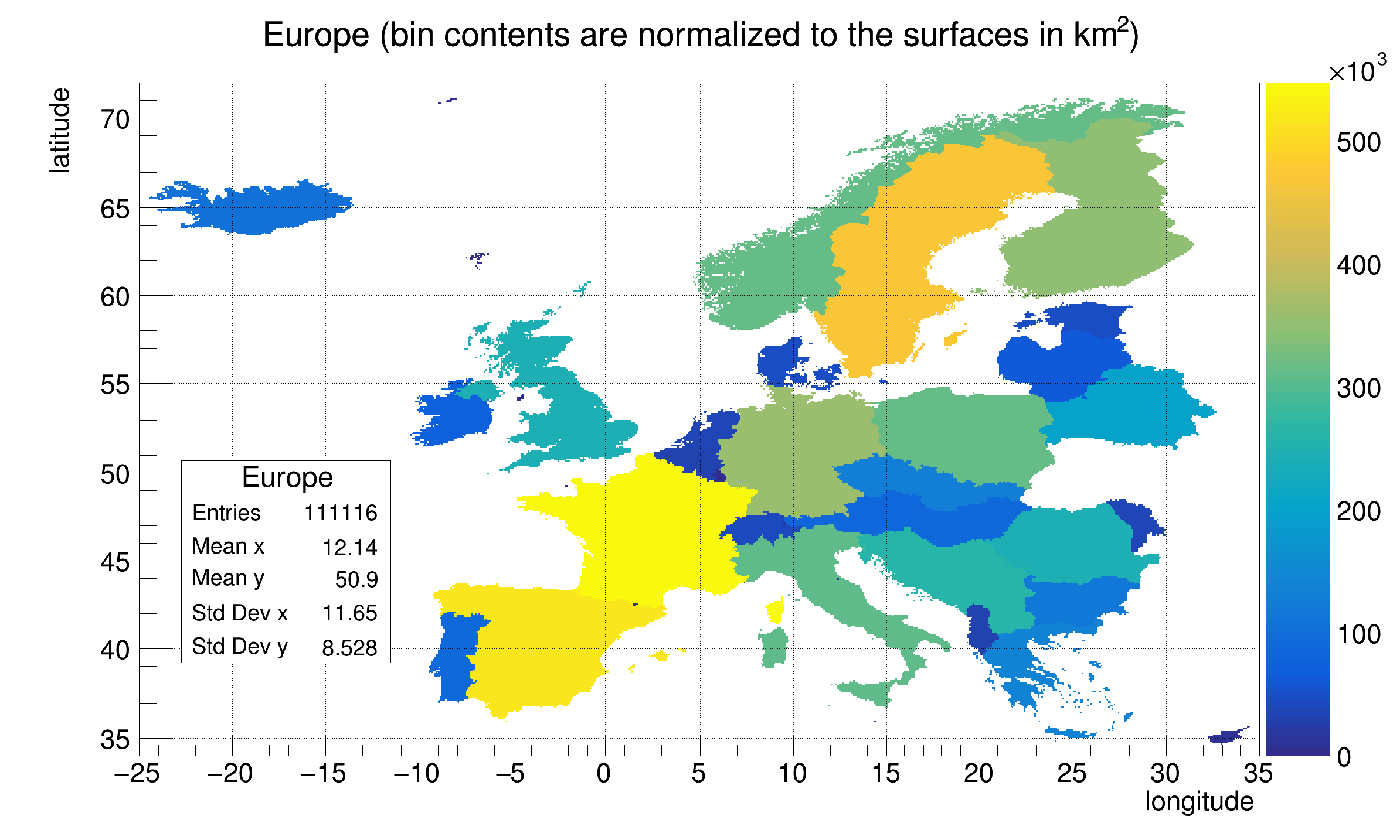
th2polyEurope.C File Reference

Detailed Description

View in nbviewer Open in SWAN This tutorial illustrates how to create an histogram with polygonal bins (TH2Poly), fill it and draw it.

The initial data are stored in TMultiGraphs. They represent the european countries. The histogram filling is done according to a Mercator projection, therefore the bin contains should be proportional to the real surface of the countries.

The initial data have been downloaded from: http://www.maproom.psu.edu/dcw/ This database was developed in 1991/1992 and national boundaries reflect political reality as of that time.

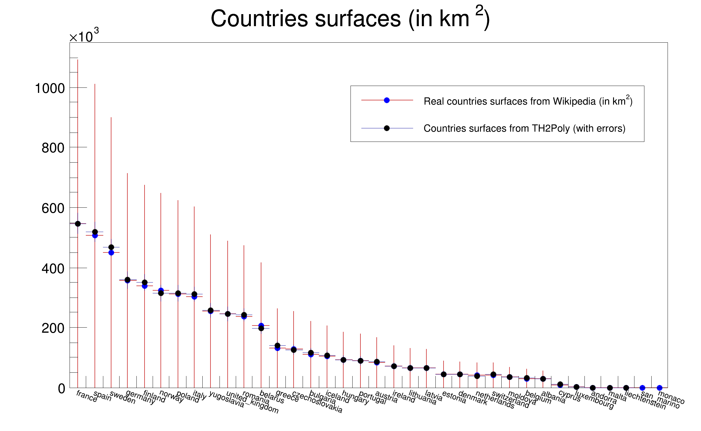
The script is shooting npoints (script argument) randomly over the Europe area. The number of points inside the countries should be proportional to the country surface The estimated surface is compared to the surfaces taken from wikipedia.

pict1_th2polyEurope.C.png
pict2_th2polyEurope.C.png
Processing /mnt/build/workspace/root-makedoc-v614/rootspi/rdoc/src/v6-14-00-patches/tutorials/hist/th2polyEurope.C...
Partitioning: Real Time = 1.16 seconds Cpu Time = 1.16 seconds
Filling : Real Time = 3.83 seconds Cpu Time = 3.83 seconds
THPoly Europe surface estimation error wrt wikipedia = 1.260096 per cent when using 500000 points
void th2polyEurope(Int_t npoints=500000)
{
Int_t i,j;
Double_t lon1 = -25;
Double_t lon2 = 35;
Double_t lat1 = 34;
Double_t lat2 = 72;
Double_t R = (lat2-lat1)/(lon2-lon1);
Int_t W = 800;
Int_t H = (Int_t)(R*800);
gStyle->SetStatX(0.28);
gStyle->SetStatY(0.45);
gStyle->SetStatW(0.15);
// Canvas used to draw TH2Poly (the map)
TCanvas *ce = new TCanvas("ce", "ce",0,0,W,H);
ce->SetGridx();
ce->SetGridy();
// Real surfaces taken from Wikipedia.
const Int_t nx = 36;
// see http://en.wikipedia.org/wiki/Area_and_population_of_European_countries
const char *countries[nx] = {
"france", "spain", "sweden", "germany", "finland",
"norway", "poland", "italy", "yugoslavia", "united_kingdom",
"romania", "belarus","greece", "czechoslovakia","bulgaria",
"iceland", "hungary","portugal","austria", "ireland",
"lithuania", "latvia", "estonia", "denmark", "netherlands",
"switzerland","moldova","belgium", "albania", "cyprus",
"luxembourg", "andorra","malta", "liechtenstein", "san_marino", "monaco" };
Float_t surfaces[nx] = {
547030, 505580, 449964, 357021, 338145,
324220, 312685, 301230, 255438, 244820,
237500, 207600, 131940, 127711, 110910,
103000, 93030, 89242, 83870, 70280,
65200, 64589, 45226, 43094, 41526,
41290, 33843, 30528, 28748, 9250,
2586, 468, 316, 160, 61, 2};
TH1F *h = new TH1F("h","Countries surfaces (in km^{2})",3,0,3);
for (i=0; i<nx; i++) h->Fill(countries[i], surfaces[i]);
TFile *f;
f = TFile::Open("http://root.cern.ch/files/europe.root","cacheread");
if (!f) {
printf("Cannot access europe.root. Is internet working ?\n");
return;
}
TH2Poly *p = new TH2Poly(
"Europe",
"Europe (bin contents are normalized to the surfaces in km^{2})",
lon1,lon2,lat1,lat2);
p->GetXaxis()->SetNdivisions(520);
p->GetXaxis()->SetTitle("longitude");
p->GetYaxis()->SetTitle("latitude");
p->SetContour(100);
TKey *key;
TIter nextkey(gDirectory->GetListOfKeys());
while ((key = (TKey*)nextkey())) {
TObject *obj = key->ReadObj();
if (obj->InheritsFrom("TMultiGraph")) {
mg = (TMultiGraph*)obj;
p->AddBin(mg);
}
}
Double_t longitude, latitude;
Double_t x, y, pi4 = TMath::Pi()/4, alpha = TMath::Pi()/360;
gBenchmark->Start("Partitioning");
p->ChangePartition(100, 100);
gBenchmark->Show("Partitioning");
// Fill TH2Poly according to a Mercator projection.
gBenchmark->Start("Filling");
for (i=0; i<npoints; i++) {
longitude = r.Uniform(lon1,lon2);
latitude = r.Uniform(lat1,lat2);
x = longitude;
y = 38*TMath::Log(TMath::Tan(pi4+alpha*latitude));
p->Fill(x,y);
}
gBenchmark->Show("Filling");
Int_t nbins = p->GetNumberOfBins();
Double_t maximum = p->GetMaximum();
// h2 contains the surfaces computed from TH2Poly.
TH1F *h2 = (TH1F *)h->Clone("h2");
h2->Reset();
for (j=0; j<nx; j++) {
for (i=0; i<nbins; i++) {
if (strstr(countries[j],p->GetBinName(i+1))) {
h2->Fill(countries[j],p->GetBinContent(i+1));
h2->SetBinError(j, p->GetBinError(i+1));
}
}
}
// Normalize the TH2Poly bin contents to the real surfaces.
Double_t scale = surfaces[0]/maximum;
for (i=0; i<nbins; i++) p->SetBinContent(i+1, scale*p->GetBinContent(i+1));
p->Draw("COLZ");
TCanvas *c1 = new TCanvas("c1", "c1",W+10,0,W-20,H);
c1->SetRightMargin(0.047);
scale = h->GetMaximum()/h2->GetMaximum();
h->SetStats(0);
h->SetLineColor(kRed-3);
h->SetLineWidth(2);
h->SetMarkerColor(kBlue);
h->SetMarkerSize(0.8);
h->Draw("LP");
h->GetXaxis()->SetLabelSize(0.03);
h2->Scale(scale);
Double_t scale2=TMath::Sqrt(scale);
for (i=0; i<nx; i++) h2->SetBinError(i+1, scale2*h2->GetBinError(i+1));
h2->Draw("E SAME");
h2->SetMarkerStyle(20);
h2->SetMarkerSize(0.8);
TLegend *leg = new TLegend(0.5,0.67,0.92,0.8,NULL,"NDC");
leg->SetTextFont(42);
leg->SetTextSize(0.025);
leg->AddEntry(h,"Real countries surfaces from Wikipedia (in km^{2})","lp");
leg->AddEntry(h2,"Countries surfaces from TH2Poly (with errors)","lp");
leg->Draw();
leg->Draw();
Double_t wikiSum = h->Integral();
Double_t polySum = h2->Integral();
Double_t error = TMath::Abs(wikiSum-polySum)/wikiSum;
printf("THPoly Europe surface estimation error wrt wikipedia = %f per cent when using %d points\n",100*error,npoints);
}
Author
Olivier Couet

Definition in file th2polyEurope.C.